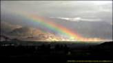
Beyond the clouds….Ladakh is changing !!
The urge to live mighty Himalayas finally paved way for a journey to Ladakh and an intense reading assured that the first journey was destined to be Manali-Leh by surface. Me, being a Wildlifer hobbyist for many years during previous India visits and immense confidence in Gypsy was prime reason to select GypsyKing.
Preparation
A few thoughtful months and driving ambitions generated issues like Checklist, GPS mappings, health hazards, Photo/Video gear and Gypsy.
I bought GypsyKingHT (my third Gypsy) MPFI 1,3 Litre. Goodyear Wrangler M+S RT/S tubeless (courtesy Rudra’s suggestion), underbelly paint, Hella Rallye3000 Blue H1 (with relay) on Rooftop, external GPS antenna (Garmin GA27C), 220volt adapter, Philips 100Watt (without relays) Headlamp bulbs and no engine or body mod. After first run-in, we started this trip with Odometer at 02625kms. Although, Manali-Leh route is fixed, GPS (Garmin GPSMAP60CS) gives the possibility to Sync Camera Date/Time to later refer Photos to exact location. Also to charter speeds, locations and elevation along the route for later reference. The last touch-ups on phones/mails with Rudra, finally summed-up the preparation for this journey and upon his arrival on 28th July in Delhi, the scene was set for this trip.
The journey
Delhi-Mandi (29.07.06)
Start 06.50hrs. Finish 17.30hrs. Distance 444km. Time 10h40m. Average 42kmph
Heights 250-1100mtrs
Left Delhi at 06.50hrs and GPS started logging. 246km Delhi-Chandigarh route logged 4h42m averaging 52kmph (top speed 106km after Karnal). Besides two of us, 200kg baggage included Photo/Video gear, personal luggage, empty army Jerrycans, emergency tools etc. in plastic containers stacked on each other for stability and easy handling. Gypsy hugged the road nicely. Rudra’s advise to go via Ropar instead of Nalagarh was right as Nalagarh route is under repairs.
Bilaspur-Mandi drive along Beas river gives first glimpses of mountains. The road nicely curves through lower hills (500-1000mtrs). Before Mandi, we overnighted at Hotel Valley View on highway. AC rooms (INR2200) and non-veg meals, though a bit over-priced, offered us just the needed overnight.
Mandi-Manali (30.07.06)
Start 08.40hrs. Finish 12.55hrs. Distance 117km. Time 4h15m. Average 28kmh
Height 780-1860mtrs
Overnight at Mandi was essential as we reached fresh in Manali using the day for final checks before leaving civilized world behind us.
Mandi-Manali journey is a pleasure winding through curves, driving alongside valley after Pandoh and going through newly built tunnels. As we drove through this route, the lush green valleys washed out in recent rains were a treat to eyes.
Our overnight at Nirmalas Guesthouse run by Danial, a Swiss married to a Manali woman gave us the final checks. Talks with Daniel (an expert on Ladakh treks) and his pleasant wife Nirmala summed up the evening after a round of Rudra’s famous evening drinks. For your reference: Daniel Liebendorfer (E-Mail: himalpin@hotmail.com).
We were now mentally, physically and technically prepared for this Photographic exposure.
Manali-Keylong (31.07.06)
Manali-Rohtang
Start 08.10hrs. Finish 10.30hrs. Distance 44km. Time 2h23m. Average 18kmh
Heights 1850-3973mtrs
Fuel consumption Delhi-Manali 13.8kms per Litre….Wow..New Engine !!
We filled tank and noted the reading to calculate fuel consumption later.
The road to Rohtang Pass is reasonably good except for few patches. Some bends are quite sharp and at one place we even used Low x4. Recent rains and trucks had made nice cocktail of sharp stones and slushy mud. It wasn’t an issue but initially when you start the first climb, carelessness could cost heavy. As a rule, on uphill and downhill curves, must goto lower gear before attempting the curve to have enough torque or engine breaking for any eventualities. The weather held and with a fully loaded Gypsy, we reached Rohtang Pass around 10.30hrs.
The drive to Rohtang Pass is more interesting compared to the flat and dirty Rohtang Pass. Thanks to day visitors.
Rohtang-Keylong
Start 10.40hrs. Finish 15.20hrs. Distance 60km. Time 4h40m. Average 13kmh
Heights 3973-3100mtrs
 Downhill to Koksar (3200mtrs) with 16km in 1hr, the road condition went bad and we crawled down. Funnily, we forgot to shoot Rohtang Pass realizing this only in Delhi at the end. On the other hand, there was hardly anything to shoot at Rohtang Pass. Koksar is a small shaggy collection of tents popping-up during summer months. After a sugary Mango juice, we drove further.
 Sissu, a few kms away, has even a tree plantation project. The road along the river has lovely valley on left and little hutments on right, hustled together looking at Rohtang Pass. The drive is beautiful except for roads. Settled in GypsyKing seats, surprisingly much comfortable to its previous models. I even laughed when Rudra mentioned that…knowing he has an Optra. The road is broken from Koksar to Keylong. It looked like an endless task for those BRO guys to bring it back to shape.
 We filled tanks in Tandi (the last patrol bunk before Leh) now having 38Litres in Gypsy and 40litres in two Jerrycans. The Gypsy fuel consumption stood at 13.8kms per Litre all through Rohtang, fully-loaded till brink.
Hotel Snowland, Keylong, is basic for INR2000 non-AC rooms. We made preliminary Camera checks. The whiskies and night slowly crept on us as we crept into our beds !!
Keylong-Sarchu (01-04.08.06)
Start 08.20hrs. Finish 16.00hrs. Distance 90km. Time 7h45m. Average 11kmh
Heights 3050-4919mtrs
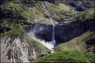
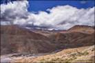
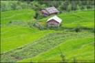
 The Keylong-Jispa (20kms) drive before Baralacha Pass is like leaning back and telling yourself that this is what you paid for. On these lower heights, the vegetation, villages, valleys, mountain colors, clean fresh air, river-side road and flora and fauna, all make together unforgettable memories…lower mountain beauty, in all respects. As we approached the Pass, the vegetation, villages and flora and fauna slowly vanished, except the bumpy surface known as roads. Jispa, has a very nice small river rafting hotel, which we would have preferred instead of Keylong.
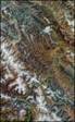
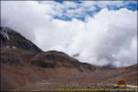
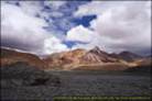
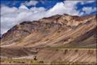
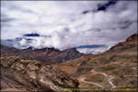
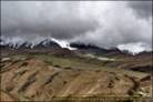
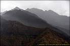
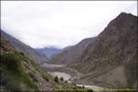 10kms ahead lies Darcha, another small settlement, after which the road winds-up towards Baralacha Pass. This road was being newly made by BRO (Border Road Org.) in extreme conditions. The Pass approach gave us first full glimpse of the mighty Himalayas. The mountain unfolds endlessly at each turn. You want to stop everywhere or ask yourselves when it would finally end.
 Trucks, Qualis, Scorpio, Mahindra, Tata Sumo were the main vehicles sighted. The Gypsy boiled when we reached the top….almost (4892 meters) ! The radiator spilled coolant. Hell ! …we said, and wished Gypsy would hold till Leh. So we filled plain water in the overflow tank and waited for it to cool down. The coolant was quite diluted with water !! The after-market AC coil board blocked the thin air reaching the radiator-fan. Revving the engine in lower gear to draw more air worked. Without any further problems, watching the temperature gauge, we drove further.
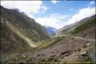
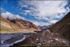
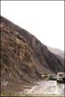
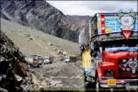 Downhill, before Sarchu, came our first glimpse of washed out road, with only sharp-edged rocks forming a make-shift path. Sharp edged stones during land-slide are far more dangerous than normal mountain streams with rounded pebbled stones. Not the ground-clearance but side-walls of tubeless tyres were a problem. The Gypsy mastered it with no issues and we reached Sarchu.
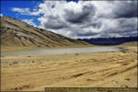
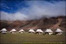 Sarchu, on flat plains has few camping tents and mountains as back-drop. The deep lying river is on left-hand-side.
The Raspian Camping Ground tents, booked through Daniel (full-board INR1400 with attached toilet and sink) awaited us. Generator electricity 19.30-22.30hrs. No electric sockets to charge batteries. The 220V adapter in Gypsy helped us. Early dinner 19.30- 21.00hrs. When they saw our photo-gear with a promise to shoot their property, they were even more flexible. Cheers….!!!
 The nights in these areas are cold and windy. The Camp provides thick blankets and hot water on demand.
Baralacha Pass and Sarchu (4400mtrs), gave me a bit of headache. Next morning Rudra had blocked nose. First symptoms of height related health problems which we decided to watch a bit.
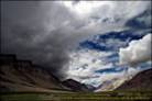
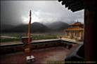
 We took the next day easy. In the evening it rained, first slowly, then with thunder and lightening. It didn’t disturb us in bed but it rained all night.
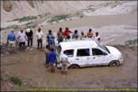
 Next morning came the first road-block news. The land-slide had washed the road. We were also concerned of road conditions further on the route. Weighing options, we extended another night at Sarchu. Later when we visited the site, a British group leaving for Leh inspite of warnings was still there knee-deep in stone and mud fighting to take out their stuck vehicle. The driver tried to rev wheels and consequently both back tyres burst, cut by sharp stones below the harmless mud.
Sarchu-Leh (04-09.08.06)
Start 06.20hrs. Finish 21.00hrs. Distance 247km. Time 14h30m. Average 17kmh
Heights 3225-5320mtrs.
 The rough road of Rohtang was luxurious compared to the road after Sarchu. Roads were partly washed out or filled with stone and water. The seemingly harmless roads were jagged enough to reduce speed to 5-10kmph. The bumps were more bumpy. It had never rained in Ladakh like this for many years, catching all by surprise.
 Slowly but surely our Photography trip turned into an Adventure trip. At places, we kept away from road on soft mud looking down at tracks of the heavy trucks (few still stuck like sitting warnings).
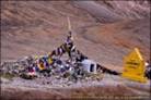 Then the famous Gata Loops (21 in all), an upward sharp curving road towards Nakeela Pass (4930mtrs 53kms from Sarchu camps). One does not notice this Pass as the road all around is on high altitude.
This is followed by a slight downhill drive and the next ascent to Lachulung Pass (5063mtrs 9kms from Nakeela Pass).
 From Lachulung Pass, it took us 1h50m downhill drive (20kms) to reach Pang.
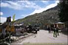
Like other places, Pang is also a few Ladakhi tents with bits of activities. A small dormitory overnighting with large army presence nearby. A small break and a 300-350mtrs climb brought us to More Plains (a vast flat plains road 45kms at 4600-4800meters) with reasonably good road conditions.
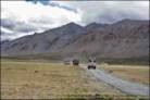 But you cannot drive more than 45kmph on this bumpy road.
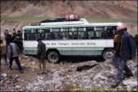
 On this stretch, a part was being repaired and traffic diverted to soft surface beside the road, a mixture of mud and small pebbles. The rains made this surface like a sinking ground. A false move would sink our vehicle in the soft terrain and then all we could do was to wait for someone. Also here a tourist bus was stuck and waited for any rescue.
 After these 45kms we started climbing for Taglang Pass (5320mtrs) for 15kms in 1hr reaching the Pass at 14.30hrs. From Sarchu, it took us 142kms in 8h10m averaging 17kmph.
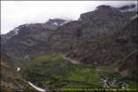
 And the next 104kms took another 6h20m although it’s down all the way from 5300meters to 3400meters. The downhill road was in a mess with chocolate colored mountain-mud water flowing on the road. At a village, the water was knee deep and just 20 meters away fallen rocks and boulders cut the road. Slowly with villager’s help, the road was cleared. And next turn after 100 meters, we saw an army jeep fully into mud in another land-slide. Even huge army truck couldn’t go through. Another wait for 2 hours till a make-shift road for us to cross.
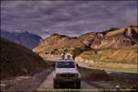
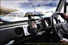
 As we drove alongwith other vehicles, it slowly turned dark. Seeing clear road, local drivers started speeding. We too increased speed to keep-up with convoy switching-on Hella lights. The powerful beams lighted the next 400mtrs like daylight. We drove at maybe 70kmph with this convoy. Luckily, we tagged behind them as further down, the road was again washed away. The local drivers fortunately knew the terrain and we followed them through this slush to be back on road after few hundred meters. Loosing their sight in total darkness would have caused us great difficulty to find next link in the road. And then it started raining heavily !! Now on firm roads, we were not concerned. At that moment, our thoughts were to find a decent Hotel in Leh.
 We hit Hotel Royal Palace at 21.00hrs (INR2970 with Full-Board). Small restaurant, generator electricity 19.30-22.30hrs and hot water 06.00-10.00hrs. Leh has acute electricity problem. A days discussions over a stiff drink followed by a nice Indian dinner made our day…what a day!! Talking of drinks, we never got drunk which at high alt. can be dangerous due to dehydration and over-exposure in the night. The drinks always relaxed us a bit….and maybe a little tiny bit more than that…what would you say Rudra..???
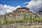
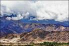
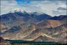
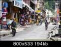
 5 nights in Leh ready with Innerline permits (courtesy Naveen Dhyani from TeamBHP forum) for Nubra Valley, Pangong and Tso Moriri lake…great !!. Ha..ha..!! all roads out of Leh were badly damaged and closed. Our worry was rather if we could drive back at all. Reluctantly, we gave up these excursion ideas and concentrated on shooting Leh and its surrounding Monasteries.
 Although we never faced any heat-up problem with Gypsy except for the first one at Baralacha Pass, in Leh, we still emptied the Radiator, had it washed and filled-in new Coolant without any mix. After 4 days with other roads still closed, we decided to drive back.
All along Manali-Leh route, mobile phones are a sure uncertainty. STD is available in Keylong, near Jispa and then only in Upshi or near Leh. Airtel is active but not all region. If you have BSNL, maybe you are lucky….maybe !!
The back journey
 On 9th August, at 07.30hrs, we headed back. The only way was to go ahead and live mother nature first-hand. Which we did. The return journey was even worse. After our arrival in Leh, the Manali-Leh route experienced further rains and bad roads became an understatement.
On bad patches, BRO usually puts cobbled stones and tops it up with plain mud…in most areas prone to water. The mud was washed away leaving only stones on the road. The mountain streams were in full swing. 100kms from Leh, we crossed a big wide stream with 40cms fast water. A Qualis had tough time, a Scorpio had water above its exhaust and sat like a Duck trying desperately to fly-off, finally making it…and perhaps ruining its back-tail !! In Low x4, the Gypsy crossed without problems.
After an overnight in Sarchu, we headed the next day towards Manali. At Rohtang Pass, we decided not to fill-in extra fuel as we felt that this Gypsy would make it to Manali. And it did…on a single full tank from Leh to Manali through all ups and downs and one hell of a road. 465kms in 33 litre (5 Litres still in tank) averaging 14km per litre.
 With 2 overnights at Holiday Inn (INR3500 on half-board per night) in Manali and 1 in Mandi, we reached Delhi on 14th August late evening, after massive traffic jam outside Delhi due to security-checks for 15th August. Luckily, we were not stopped as we would have tough time to open and close all photo gears.
The Goodyear Tyres did not require any checks and till Delhi we never felt the need to check the pressure although we carried a manual air-pump. Not even single scratch on Gypsy. On way back the sweet engine hum was like music to us.
 Thinking back, we both felt that although we had such bad weather but then seeing the positive side, we consider ourselves lucky enough to have experienced these conditions which others probably will not. And what a drive it was….suspense waiting at every bend throughout….memories !!
 For everybody here who wants to visit Ladakh in future: Ladakh is changing. Probably one of the very first examples of global warming (or global warning, whichever you prefer). Twelve days of continuous rain was the first time there. Or so the locals said. We hardly saw clean blue sky. There was hardly any road on our way back. Is it possible for army and BRO to make a clean good road right through? Maybe yes, if right technological know how can be applied in right time and in right way. Maybe not, if we realise what destructive power can mother nature bring in.
Photographs
Photos are on Canon gear with various lenses. From over 1000 pics in RAW, selection criteria being more importantly distribution of pics along the route.
GPS remarks
Although Images are Geocoded, their location in Google Earth is not available.
© Ajay Narayan
Dated: 8th October 2006, Zürich
www.ajaynarayan.com