2007 Ladakh
The thought
In the summer of 2006, our visit to
Ladakh was marred by the heaviests of rainfalls that this area witnessed in
many decades. We were caught right in the middle of the downpour and had to cut
short our trip limiting to only Manali-Leh-Manali (see Ladakh 2006 on this Website). On our way
back to
Unfortunately, Rudra could not join me
on this trip due to prior commitments, so I decided to do this trip alone.
I picked up a guide from Manali to
accompany me as I had promised my wife not to do this trip alone.
The preparation
The Gypsy King 1.3Liter (make April
2006) was serviced (Odometer at about 15000kms). I just got it washed and
cleaned since the last service was done only few months back. The radiator
fluid was changed in full concentrate without any water-mix. Further, due to
A/C radiator and fan being in front of the main cooling radiator, I installed
additional circuit Switch which operates the A/C radiator fan even when the A/C
is not running. This gives the benefit that on high altitude, the A/C fan
together with the radiator fan gives more than enough cooling even at 5600mtrs.
Never had a cooling problem anymore.
An addition to my check-list was
Solar-powered 7500mAH battery for extensive usage. I could keep it switched-on for the
whole evening to have enough light without any problems.
I went through my usual over 200 article
check-list to ensure that nothing is forgotten.
The roads
The road conditions throughout this trip
was very mixed, from non-existant to extremely good in parts. At many places the
roads were either being repaired, broadened or newly made.
There is a new stretch of road under
construction between Darcha and Padum as also between Leh and Padum. These
additions mean that Padum will be easily accessible from Lahaul valley and also
from Leh. One will not have to go via Kargil. Furthermore, once the tunnel of
Rohtang starts functioning, also
The Passes
I covered in all 12 passes. Only 3
passes were not crossed twice i.e., Nakeela, LachulungLa and TaglangLa pass as
we came from Leh to Keylong via Tso Moriri and Tso Kar. So in all we crossed 21
passes to cover this entire journey. That’s a lot of passes, I
guess…!
I have mentioned the names of the passes
on each route for your reference.
The Photographs
I came back home with over 2700
photographs in RAW format (3456x2304x48bit). I was using Canon350D with two
L-series Lens 24-105mm and 100-400mm. The idea to shoot so many pics (about
40GB Harddisk space) was not only to capture some nice moments but also capture
a photographic record of the entire stretch. Out of this collection, I prepared
some 170 pictures which cover most of the stretch and the places that I
visited. I did not get inside many
Gompas as in most of them photography is not allowed and after seeing few
Gompas, I could bypass others. There is also a collection of 10 panoramic views
which gives a better idea of the area, terrain and the mountains. By the way,
the extreme colors in photographs especially Tso Pangong and Tso Moriri are
actual colors. I have tried best to keep the original colors at the time of
shoot without trying to influence them.
GPS logging
Throughout the journey my Garmin 60CS
was active and complete stretch has been logged. On the basis of these
loggings, all pictures have been Geocoded.
The average speed included various halts
in between and does not indicate the actual average of the moving vehicle. The
actual moving average will be slightly higher (only by few kmph). On the entire
trip the normal speed went around 18-25kmph with exceptions of going down as
low as 8kmph to as high as 60kmph.
Something about elevation loggings by
GPS. Garmin units record elevations by calculating on the basis of minimum 4
satellite data. Usually, the GPS elevation in consumer units have an error
factor. I noticed on my unit that as I went higher up, the error became larger.
Infact, on KhardungLa pass, my logging showed 5370mtrs whereas the original
height is around 5600+mtrs. All distances are shown from my Hotel and are not
from the
The 5 weeks Journey through Ladakh Lahaul Pattan Spiti and Kinnaur
valley
I am not mentioning the journey between
Delhi-Manali-Delhi except GPS details.
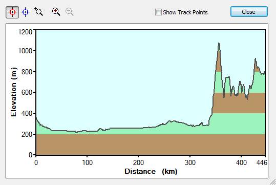
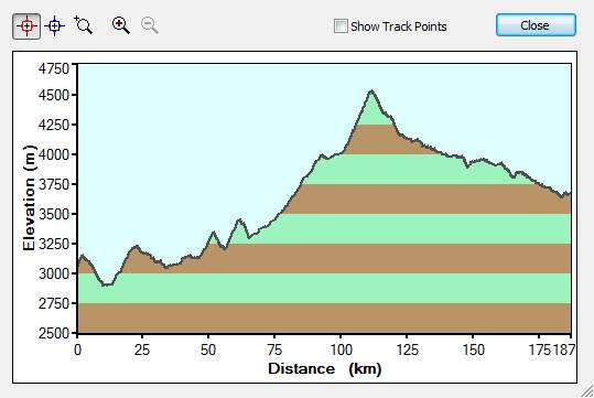
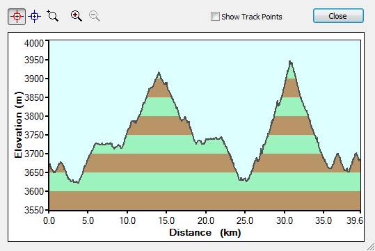
I have also inserted elevation profile
for this trip which shows the distance and the respective elevation of the
stretch giving you an idea of the ups and downs w.r.t. covered distances.
10th July 2007
Start 07.03hrs. Finish 17.36hrs.
Distance 446kms. Time 10h 33m. Avg 42kmph
Overnight:
The sudden height gain above is as you
get into Bilaspur area.
Accommodation: Hotel Valley View 9km before Mandi ca.1500INR for A/C room. Meals
separate.
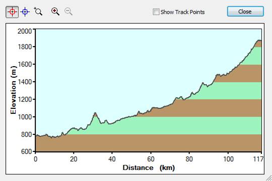
11th July 2007
Mandi
(from
Start 09.26hrs. Finish 13.06hrs.
Distance 117kms. Time 3h 40m. Avg 32kmph
Accommodation: Nirmala’s Guest House ca.1000INR for room. Meals separate.
13th July 2007
Manali
– Keylong (
Start 10.13hrs. Finish 16.26hrs.
Distance 111kms. Time 6h 13m. Avg 18kmph
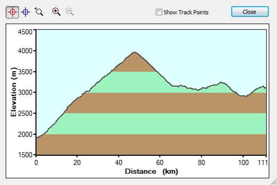
The peak is
Accommodation: Hotel Snowland ca.1000INR for room and meals per night.
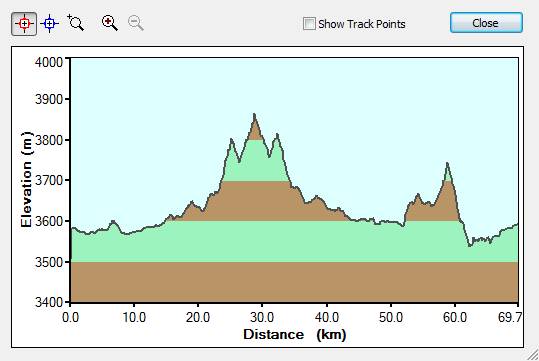
14th July 2007
Keylong
– Triloknath –
Start 09.54hrs. Finish 17.04hrs.
Distance 121kms. Time 7h 09m. Avg 17kmph
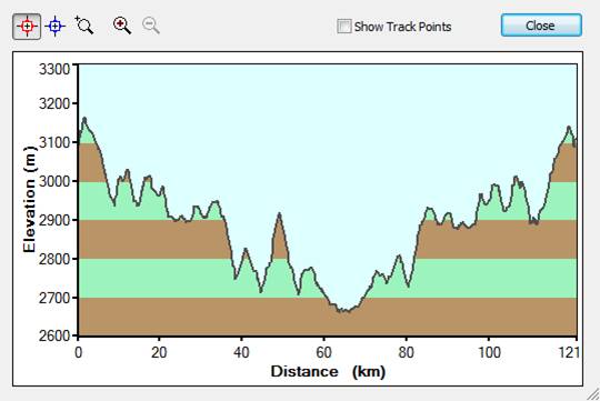
This part of the valley is very
beautiful and roads are not bad at all. The
The lowest point in the elevation is the
bridge which needs to be crossed to go to
Slides: IMG_0848, IMG_0874, IMG_0878
15th July 2007
Keylong
– Sarchu (
Start 09.03hrs. Finish 13.15hrs.
Distance 88kms. Time 4h 12m. Avg 21kmph
After Darcha, the climb for Baralacha
pass (around 5000mtrs) starts. We hit the bad weather at Baralacha pass which
is famous for very fast deteriorating weather conditions. The visibility was
quite limited but we did not have any problems. The 2nd night in
Sarchu I felt the height and for the next 2 nights I was really worthless. The
2nd night I took an Aspirin which helped me and from the next day
onwards and I never had the AMS problem on the entire trip anymore. A piece of
advise – if you feel the height, don’t go for Diamox but rather
take an Aspirin. Diamox delays the AMS symptoms which may reoccur later in the
trip. If you still have AMS problem, then you must extend your halt till you
feel alright. In worst case, you must go back to lower heights as for AMS there
is no medical cure as such.
Accommodation: Raspian Camp. Tent with
meal ca.1800INR per night.
Slides: IMG_0885
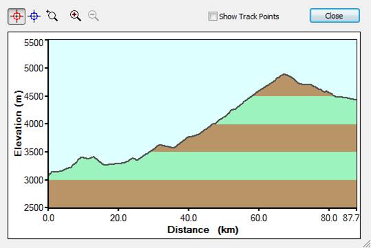
17th July 2007
Sarchu
– Leh (Nakeela, LachulungLa and TaglangLa pass)
Start 08.04hrs. Finish 17.10hrs.
Distance 252kms. Time 9h 06m. Avg 28kmph
On this track, you pass NakeeLa (above
4900mtrs) , LachulungLa (above 5000mtrs) and TaglangLa (above 5300mtrs) passes.
In fact, TaglangLa pass is the second highest pass after KhardungLa pass. You
also go through Moré Plains on this track. The roads were being made and
many places you are fully in dirt track, at places you need to be very careful
unless you want to get stuck for good…!
Accommodation: In Leh there are plenty of Hotels. I paid ca.2800INR for A/C room and
all meals. But you have plenty of choice here. In peak season you may have to
hunt a bit but I don’t think that you will land up spending night in the
open.
Slides: IMG_0902pan
20th July 2007
Leh
– Kargil via Alchi and Lamayuru Gompa (FotuLa and NamikaLa pass)
Start 07.41hrs. Finish 17.45hrs.
Distance 218kms. Time 10h 04m. Avg 22kmph
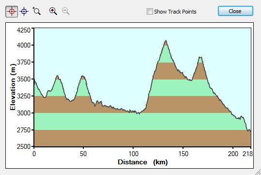
The terrain is a lot of muddy mountains
and roads full of dust. The roads are being broadened and at many places you
may have to wait till the section is cleared for traffic. Just around Nimu
where Zanskar and
Accommodation: Hotel D’Zojila room ca.1000INR. meals separate.
Slides: IMG_0927, IMG_0937, IMG_0949,
IMG_0951, IMG_0960, IMG_0978, IMG_1005, IMG_1010, IMG_1033, IMG_1045, IMG_1051,
IMG_1060, IMG_1080.
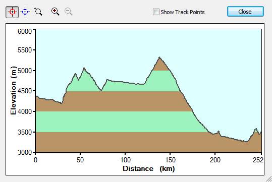
21st July 2007
Kargil
– Padum (PenziLa pass)
Start 08.02hrs. Finish 21.40hrs.
Distance 226kms. Time 13h 37m. Avg 17kmph
When you start from Kargil, you
don’t know what is waiting for you. The road condition gets bad and bumpy
almost till Partek. Then the bumps get less but the road condition is
practically village road all the way till Padum. That’s why you see the
stretch of 226kms in over 13hours. There are two peaks on this track Nun and
Kun. I do not think that Nun (above 4600mtrs) can be spotted from the road but
in reasonable weather you can see the majestic Kun (above 6300mtrs) and some of
the Glaciers (Fariabad glacier in IMG_1130) which comes down to melt in the
river. The sights are worth the trouble of driving conditions. The flat plains
around Ringdom Gompa sitting on a hillock looks grand from a distance. The area
is full of stone pebbles and swamps. Then comes the pass of PenziLa and the
fantastic sight of Durung Drung Glacier makes your day. The rest of the journey
is along Doda river all the way to Padum. For us it was soon to be dark and I
had to switch-on the big Hella lamps mounted on the roof-top. There after I
could drive reasonably well all the way to Padum. When we reached there in the
late evening, there was no electricity. It was a chaos till we finally found a
Hotel (highly priced ca.800INR for the night). The next day we changed the
Hotel.
Accommodation: Hotel Ibex ca.350INR per night. Meals separate.
Slides: IMG_1083, IMG_1103, IMG_1106,
IMG_1112, IMG_1123, IMG_1130, IMG_1145, IMG_1147, IMG_1163, IMG_1164, IMG_1165,
IMG_1176, IMG_1181, IMG_1207, IMG_1223pan.
23rd July 2007
Day
Excursion around Padum area
Start 10.02hrs. Finish 16.11hrs.
Distance 70kms. Time 6h 9m. Avg 11kmph
The visit to Sumchum and Karsha Gompa
are worth a visit. Sumchum is hidden in a valley and Karsha is overlooking the
grand
Slides: IMG_1235, IMG_1261, IMG_1308, IMG_1316, IMG_1320,
IMG_1338pan, IMG_1379.
24th July 2007
Day
Excursion around Padum area
Start 10.37hrs. Finish 20.00hrs.
Distance 136kms. Time 9h 23m. Avg 15kmph
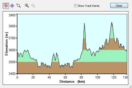
The above 9h 23m include 1h 30m
lunch-break before we went to Burdun and Mune Gompa. In the late morning, we
went to see how far the construction of the road between Padum and Leh is
completed. Well, we could drive upto 50kms on this road almost where the rocky
part starts and the rock blasting is being done. And then in the afternoon we
went to see Burdun and Mune Gompa. The road to Burdun and Mune Gompa are still
worse. From Mune Gompa we turned back, not because of the road but the terrain
seemed to be similar to what we had seen.
Slides: IMG_1382, IMG_1394, IMG_1408,
IMG_1432, IMG_1433, IMG_1436, IMG_1443, IMG_1454, IMG_1464, IMG_1485, IMG_1507,
IMG_1513, IMG_1533, IMG_1552, IMG_1558, IMG_1565, IMG_1585.
25th July 2007
Padum
– Partek (PenziLa pass)
Start 08.39hrs. Finish 17.59hrs.
Distance 171kms. Time 9h 19m. Avg 18kmph
The elevation profile is similar as on
the way from Kargil to Padum
Instead of driving uptill Kargil, we
stopped on way at J&KTDC Rest House at Partek (or Partichek). The full
clear view of peak Kun was just great.
Accommodation: Jammu & Kashmir
Tourism Development Corp. Rest House. Room with meals ca.300INR
Slides: IMG_1600, IMG_1606, IMG_1621,
IMG_1665, IMG_1681, IMG_1702.
26th July 2007
Partek
– Kargil – Leh (NamikaLa and FotuLa pass)
Start 07.16hrs. Finish 17.53hrs.
Distance 259kms. Time 10h 37m. Avg 24kmph
The elevation profile is similar as on
the way from Kargil to Leh
The way back to Leh included few stops
for road clearing and it was dusty all the way. The worst is when you come
behind a truck which is throwing dust like a blower.
Slides: IMG_1789.
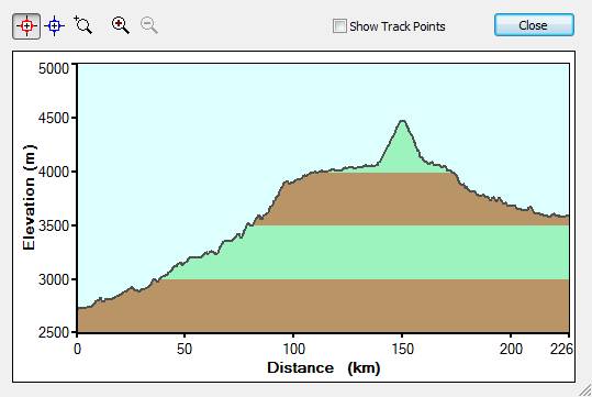
30th July 2007
Leh
– Nubra valley (
Start 09.00hrs. Finish 14.47hrs.
Distance 105kms. Time 5h 47m. Avg 18kmph
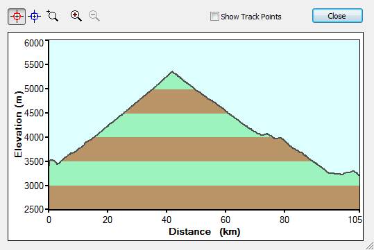
For Nubra valley it’s just all the
way up and then all the way down. And as you can see, it’s over 2000mtrs
climb in about 45kms. The roads are slightly better and were being repaired.
The view of Leh from top is extremely nice especially getting a glimpse of a
large portion of the valley. The KhardungLa pass is full of day-return
tourists. I will not be surprised if they open Malls there and in few years you
may even do some shopping there. The descent is equally steep. The distance to
Nubra is not so much compared to what we already had behind us.
Accommodation: Tirit Tents. Tent with full meal ca.1800INR per night.
Slides: IMG_1809, IMG_1817pan, IMG_1853, IMG_1859,
IMG_1865, IMG_1878, IMG_1904.
31st July 2007
Day Excursion
in Nubra valley
Start 08.49hrs. Finish 16.34hrs.
Distance 143kms. Time 7h 45m. Avg 18kmph
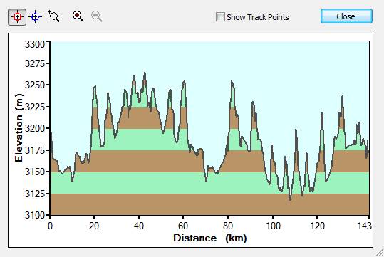
The
Slides: IMG_1937, IMG_1972, IMG_1993pan,
IMG_2021, IMG_2047, IMG_2077, IMG_2096, IMG_2101, IMG_2119.
1st August 2007
Nubra
valley – Leh (
Start 07.25hrs. Finish 11.21hrs.
Distance 103kms. Time 3h 56m. Avg 26kmph
The elevation profile is similar as on
the way from Leh to Nubra valley.
The climb to KhardungLa pass from this
side is quite steep and I had to change quite frequently from 2nd to
1st gear. The road construction and the road blockage can also delay
you quite a bit. We were lucky to just get past before getting blocked.
Slides: IMG_2138.
3rd August 2007
Leh
– Tso Pangong (
Start 08.00hrs. Finish 14.12hrs.
Distance 155kms. Time 6h 12m. Avg 25kmph
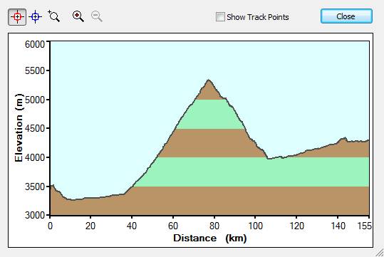
Near Karu you take a left turn if you
are coming from Leh to goto Tso Pangong. The journey to ChangLa pass (above
5400mtrs) and afterwards is quite interesting. You can see the military
presence due to closeness of the Indo-China border. The valleys are quite nice
to drive and the road leading to Tso Pangong is also reasonably good. The
J&KTDC accommodation is the only good option for overnighting there.
It’s bare basics and you need to reserve in advance to avoid problems on
the spot. Tso Pangong can be very blue and with the light changing, one can
have different views all the time. You can do little bit of driving around but
your permits are controlled quite well by the army post there.
Accommodation: J&KTDC Rest House. Full board ca.1800INR per night.
Slides: IMG_2154, IMG_2176, IMG_2178,
IMG_2182, IMG_2188, IMG_2201, IMG_2230, IMG_2244, IMG_2260, IMG_2280, IMG_2304,
IMG_2314, IMG_2321, IMG_2345, IMG_2346, IMG_2382, IMG_2497, IMG_2504.
4th August 2007
Tso
Pangong – Leh (
Start 08.53hrs. Finish 14.26hrs.
Distance 155kms. Time 5h 33m. Avg 28kmph
The elevation profile is similar as on
the way from Leh to Tso Pangong.
Slides: IMG_2570pan, IMG_2582, IMG_2590, IMG_2599,
IMG_2606.
6th August 2007
Leh
– Tso Moriri (
Start 08.03hrs. Finish 15.44hrs.
Distance 210kms. Time 7h 40m. Avg 27kmph
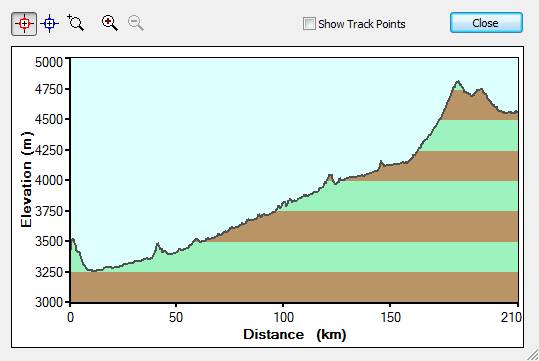
The route is to basically follow the
Accommodation: Tented overnight. Ca. 1800INR per night. You may also get bare basic
overnights (ca.500INR) in Korzok village. There are quite a few tents which
have popped-up recently.
Slides: IMG_2637, IMG_2660, IMG_2671,
IMG_2677, IMG_2684, IMG_2692, IMG_2717, IMG_2721, IMG_2734.
7th August 2007
Day
Excursion Tso Moriri
Start 16.55hrs. Finish 18.29hrs.
Distance 6kms. Time 1h 33m. Avg 4kmph
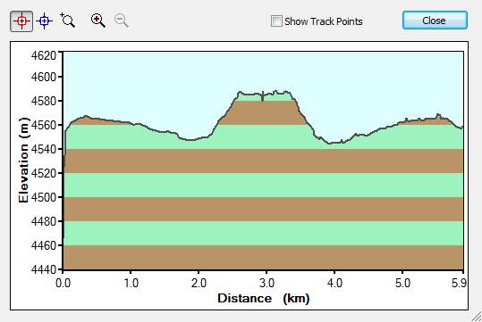
A little further (ca. 1.5kms) from Korzok
village there is one very decent point on a hill-top from where one has almost
complete view of the lake. The
weather can change here quite fast, so I recommend you taking pictures without
loosing time. In the afternoon, there can be quite strong wind and temperatures
can go down quite fast. Depending upon the weather, the clouds, the sunlight,
the wind, the temperature and yourself, Tso Moriri can become very interesting
even for a bit prolonged stay (say 3-5 nights) depending upon what you have on
mind.
Slides: IMG_2772, IMG_2774, IMG_2811,
IMG_2851, IMG_2867, IMG_2878, IMG_2892pan, IMG_2921, IMG_2942, IMG_2956,
IMG_2985, IMG_3040, IMG_3051, IMG_3071.
8th August 2007
Tso
Moriri – Sarchu via Tso Kar (NamchangLa,
Start 08.32hrs. Finish 18.34hrs.
Distance 212kms. Time 10h 1m. Avg 21kmph
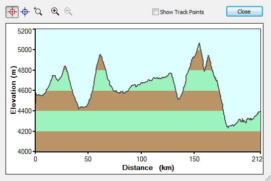
From Tso Moriri, we crossed NamchangLa
pass and came back till village Sumdo to take the diversion road to goto Tso
Kar. This road from Sumdo village till PolokongkaLa pass (above 5000mtrs) is
quite bad and I guess after bad weather it can be quite a challenge. After the
pass, till this road meets the main Leh-Manali highway, the road is being done.
It’s bumpy dirt road anyway but I saw quite a repair work going on. We
did not overnight (although we carried our tent and cooking gear) and drove
along Tso Startsapuk and Tso Kar halting inbetween for photographs. There are
salt deposits everywhere and at places its all white due to salt. Wild asses
were also spotted which are unique feature of this area. After Tso Kar the road
slowly turns left to merge on the main Leh-Manali highway. Some the route here
is still not define and after rainy season, it can hold you up for quite a
while.
Slides: IMG_3106, IMG_3109, IMG_3115,
IMG_3121, IMG_3124, IMG_3145, IMG_3183, IMG_3197, IMG_3226, IMG_3231, IMG_3246.
9th August 2007
Sarchu
– Keylong (
Start 08.23hrs. Finish 12.27hrs.
Distance 97kms. Time 4h 3m. Avg 24kmph
The elevation profile is similar as on
the way from Keylong to Sarchu.
10th August 2007
Keylong
– Kaza (
Start 07.59hrs. Finish 17.25hrs.
Distance 187kms. Time 9h 26m. Avg 20kmph
The diversion for going to Spiti valley
is about 6kms after the Koksar bridge if you are coming from Keylong. The road
starts with a downhill drive all the way till the valley level and after a
while the road is not good at all. Approaching Kunzum pass (above 5000mtrs) can
be very dusty as its all mud and earth mountains with small pebbles. Also the
road is quite narrow till Kunzum pass. Afterwards, it gets slightly better till
you come down to the valley level again. Thereafter, its all metal road till
Kaza and beyond. I have the impression that the road conditions and the
maintenance in HP area are superior to that of J&K. I also saw that PWD is
very active in the HP area. As we approached Kaza, the weather changed suddenly
and it rained quite heavily for a while but then finally it stopped. The Spiti
valley is long and the road winds through one side of the valley till you cross
the Spiti river to go on the other side to Kaza. Kaza is reasonably big and
most of the facilities exist here, including petrol pump.
Accommodation: Hotel Banjara Retreat ca.3200INR with all meals per night.
Slides: IMG_3249, IMG_3265, IMG_3275,
IMG_3288, IMG_3290, IMG_3299, IMG_3315, IMG_3327, IMG_3341, IMG_3373, IMG_3387.
11th August 2007
Day
Excursion around Kaza
Start 14.07hrs. Finish 16.04hrs.
Distance 40kms. Time 1h 57m. Avg 20kmph
We went to see Ki Gompa which is
extremely well situated on a hill. Further, the road leads to Kibbar which we
did not visit. On way back to Kaza, we wanted to goto a hilltop for even a
better view of the mountains but then the weather changed again and we could
see the mix of hot and cold air in the valley raising a huge dust strom up into
the clouds. Then I said to myself that the fine weather travel uptill now is
over and we now need to brace ourselves for few weather surprises. Promptly,
the next morning, we heard that the road to Nako is closed due to land-slide.
There was another land-slide about 10kms before Jilang on Kaza-Manali stretch.
So, we were now in between with both sides blocked due to land-slide.
Slides: IMG_3398, IMG_3402, IMG_3441.
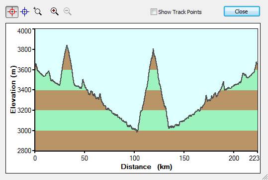
13th August 2007
Kaza
– near Nako – Kaza
Start 08.02hrs. Finish 16.33hrs.
Distance 223kms. Time 8h 31m. Avg 26kmph
As planned originally, we left Kaza to
continue our journey to Nako and beyond. We were told that the road to Nako is
blocked but we decided to take chance or at least see the condition of the
damage in order to decide how long we need to wait it the road could be
cleared. We had to miss Pine valley National Park as the road was closed due to
land-slide. Further on way we went to a steep climb to Dhankar Gompa. The last
bit of the road at the end of the hill was broken and we had to turn back from
about half a kilometer before Dhankar Gompa. The elevation peak above tells you
that the height gain is 1000mtrs within 10kms. The road to Tabo, Hurling and
then towards Nako goes along Spiti river all the way with black mud and stone
hills on both sides. There was a constant rumbling of pebbles falling on the
road. The way goes through few villages on the river side and Tabo and Hurling
being the biggest till Nako. And then after a climb through very narrow
mountain road we finally reached the site where the road was washed away. This particular zone is known for
land-slides. The mountain hill is basically loose stones and boulders sticking
together with mud and small pebble. A slight disturbance makes them fall and
the gathering boulders become a massive land-slide. It has been going on in
this area for few years and every time a new road is made. It seems that the
authorities are now seriousely making a more stable road on the other side of
the hill. Anyway, we now knew that this land-slide will take at least a week
before traffic is at apossible. This you can also see from the Images. We had
no option but to return back to Kaza and hope that the other side is open for
traffic.
Slides: IMG_3453, IMG_3477, IMG_3494,
IMG_3513, IMG_3539, IMG_3542, IMG_3562, IMG_3570pan, IMG_3587pan, IMG_3590,
IMG_3591, IMG_3600, IMG_3605, IMG_3610.
14th August 2007
Kaza
– Manali – Mandi (KunzumLa and
Start 08.06hrs. Finish 20.09hrs.
Distance 319kms. Time 12h 02m. Avg 27kmph
The elevation profile is similar as on
the way from Rohtang to Kaza, Manali to Rohtang and Mandi to Manali.
After an overnight in Kaza, we heard
that the other side is opened. There are always these unconfirmed reports from
mouth to mouth. So we decided to take a chance and in worst case, we could also
overnight in a nearby village or even in our own tents. On the way back, we saw
many other tourist taxis and buses also heading that direction, so we were
quite sure that the road was opened as the police check-post after Kaza also
confirmed the open traffic. The last slide of these Images is the place
(presumably Pagla Nallah or similar) where I parked the Gypsy to take a shot of
the road which otherwise seems so harmless.
Slides: IMG_3615, IMG_3626.
15th August 2007
Mandi
–
Start 08.46hrs. Finish 18.38hrs.
Distance 451kms. Time 9h 52m. Avg 46kmph
The elevation profile is similar as on
the way from
Between Mandi and till after Bilaspur, I
had to go through a horror scenario with at least 50 land-slides and pouring
rains with lightening and the day turned into night. I kept on driving in the
safety of the Gypsy. No cars were in sight and most of the trucks were parked.
Only few were still plying the road at a snails pace. The visibility was like
10mtrs, the wipers at full speed and still I could not see much. This stretch
of about 35kms took me about 1.5hours. The Gypsy goes through all these without
any problems and I was glad that I was sitting in such a reliable vehicle. Soon
afterwards, with the descent from Bilaspur area, the rain had stopped and the
bright sunshine came. The world was different and an hour afterwards, I had to
switch-on the A/C. Near Delhi, the security-check for in-coming vehicles on 15th August was not that high like last year. I guess that it already happened on 14th August. So I was at home at dusk.
The vehicle condition
Fuel consumption came between 12-14kmpl throughout
the hilly terrain and about 14-16kmpl on the highways with A/C on.
The 20k third service was due. Wheel
alignment, tyre rotations, engine-oil, gear and differential oil replacements
with special additives, all the under-chassis inspection, all underbelly
suspension rubber-bushes, air-filter etc. were controlled and done. This
service costed me 7’500INR. I must also give credit to Sikand Motors in
The after-thought
I would love to do this trip again one
of these years. Anyway, I will cover the missed portion of Pine valley, Nako,
Sarahan and Simla route next year after the rains.
Additional Information
Please also see the Ladakh 2006 trip
article which covers the sector Manali-Leh-Manali.
©Ajay Narayan
19th October 2007,
www.ajaynarayan.com