2010 Ladakh
Planning
My
last trip to Ladakh in 2006 with Rudra Sen was cut short by the heaviest of
rainfalls in Ladakh since many years. Infact, we could just cover Manali-Leh
route to only get stuck in Leh due to bad weather throughout Ladakh region. In
the end, we had to backtrack the way we came and that was the end of Ladakh
2006 tour !
So
we had thought to cover the region again one of these years. Originally, I had
planned to stay in Ladakh for few weeks this summer and cover the whole region.
But when Rudra got his holidays approved, we decided to make it together. That
was the end of our thought process and the start of Planning.
We
did not want to go through the same scenario like in 2006, so we planned the
trip before the rains, to get some shots of melting snow and to cover the area
before the rains hit. That decided the timing of this trip. We both wanted to
cover the route via Srinagar-Kargil-Leh even though we needed to cover almost
1000kms just to reach
Preparation
I got
the 4x4 Off-roader Maruti Gypsy King 1.3Liter (make April 2006) serviced. This
time, upon insistence of Rudra, I replaced all the tyres,
although the existing Goodyear Wrangler RTS had done only 38000kms. I wanted to
increase the ground clearance a bit more, so I imported Calmini Reverse Shackle
Suspension Kit from
Rudra
took the flight from
Route
From
the previous trips to Ladakh, I was well aware of the roads. But especially
Ladakh is a region where a single rainfall can change everything. I was never
on Delhi-Jammu-Srinagar-Kargil route. That sector was new to both of us. We
knew that Delhi-Jammu (610km) in June heat will be very demanding. We were also
aware of the security issues around
Delhi
– Jammu – Srinagar – Kargil – Leh – Nubra –
Leh – Pangong – Leh – Tso Moriri – Tso Kar – Keylong – Kaza
– Sangla – Narkanda – Simla - Delhi.
Since
the Kaza sector was still closed, we decided to follow the route from
And
so we started our journey to Ladakh.
Roads
There
is a new stretch of road under construction between Darcha and Padum as also
between Leh and Padum. These additions mean that Padum will be easily
accessible from Lahaul valley and also from Leh via Nimmu and Chilling. One
will not have to go via Kargil. Furthermore, once the tunnel of Rohtang starts
functioning, also
Weather
Like
in year 2006, this time also the weather played a major part. As we came to
Leh, almost all the passes were still having fresh snowfalls, landslides and
remained closed. We tried to cross to Tso Pangong twice but without success due
to fresh snowfall. Luckily, we could cover Tso Moriri which was extremely cold
like -6 deg. in the night with water pipes bursting. After initial blockade due
to snow, we could still cross Khardung La and reach Nubra valley to find
beautiful weather there. But on return from Nubra to Leh, we again were confronted
with fresh snowfall near Khardung La, although we could cross the pass and
reach Leh as we had planned. We waited in Leh for the Manali route or Pangong
Tso route to open. In the meantime, we could cover some local villages and a
short drive of about 80kms towards Rumtse. But the news of landslides and fresh
snow on Manali route seemed hopeless. At the end we had no option but to break
our journey and head back home back-tracking via Kargil-Srinagar-Jammu to
Return via
On
return, from Kargil to
Journey
The
Trip to Ladakh as we had planned was not completed.
The
major sector of Leh-Manali had to be dropped as well as the trip to Tso
Pangong. And we had to completely skip Lahaul and Spiti valley. The thought of
taking the route from Jammu to Manali and then to Lahaul and Spiti valley had
to be dropped as Kunzum La (the access to Kaza) was still having snowfalls and
landslides. A month trip was
reduced to 20 days and we must have overstayed in Leh for at least 4 nights.
The original thought of covering Ladakh before rains was only a partial
success. Should we have started few weeks later ? I don’t know...! As I
came back home now, I read the great tragedy of Cloud-burst in Leh and near
Nimmu on 6th August. Over 160 people have lost their lives and above
500 persons are still missing (official figures). This is just about 7 weeks
after we left Leh. And I am now sure that the rains never left Ladakh these 7
weeks. So even if we had started a bit later, the probability of completing
this Trip was quite less. At least with these thoughts, we can still console
ourselves. On the other hand, the positive side was to see the fast weather
changes including snowfalls and being able to take some images of these areas.
This has been very rewarding as we could get some really good shots.
The
final Kilometer reading came out to be 4300kms.
That
leaves me with a will to go there again and cover this region completely once
more as I initially wanted….!
Photographs
We
have been shooting this trip with Canon 1DS Mark II, 1DS Mark III and Powershot S90. All Pro L Series Lenses of 20mm, 50mm,
24-105mm, 70-200mm (4.0) and 70-200mm (2.8), 100-400mm alongwith other accessories like Tripod, Monopod Filters etc.
84
images from the total shooting are being published on this Website under Ladakh
2010 Picture Gallery.
Besides
this, we also filmed with Canon IXUS200 IS 1280x720 pix 30fps movies while
driving. Some portions of these movies are compressed to 640x480 pix in iPhone 3G format to see it also on
All
the Photographs are Geocoded. The movies are also Geocoded but I have not published the Geocodes alongwith the movies.
GPS logging
Complete
trip has been logged on my Garmin 60CS. The Google Earth Satellite image as the
first slide shows the GPS route in a Skyblue color in
Photo Gallery.
I
also carried and tested MapMyIndia console with
latest version of All India Map. I can say that within the cities, the Maps are
reasonably good including National Highways. The State Highways and roads
outside towns are unreliable. In
Besides
Garmin 60CS and MapMyIndia, I was also using PathAway Pro 5 on my HTC Sedna 6500 PPC. I have always used PathAway Pro on all my
trips and find it very comforting depending upon how good you are at map
calibration. It gives you a visual idea of the region and a sense of direction
which keeps you going. Mind you, most of the new PPC and Mobile devices DO NOT
have built-in GPS Module but only AGPS (Assisted GPS) and that includes iPhone 3G or even the latest 4G. These new Models generally
work through Telecom transmission towers and not directly through Satellites.
In a region like Ladakh, you may not get a transmission signal for miles and
keep on wondering why your GPS is not working !!!
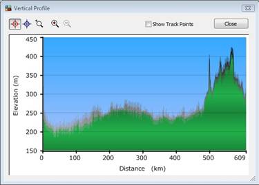
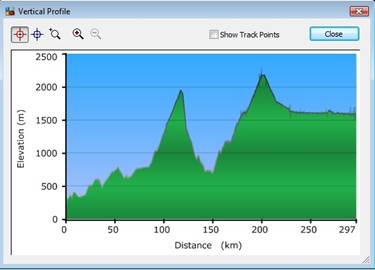
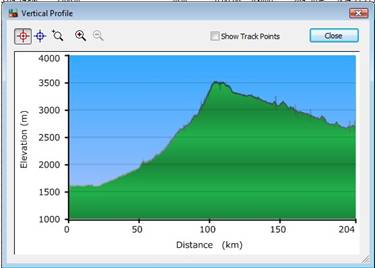
I
have included the Elevation Profiles for the sector
30th May 2010
Start
06.00hrs. Finish 20.40hrs. Distance 609kms. Time 14h 40m. Avg 42kmph
Accommodation:
Hotel Asia,
31st May 2010
Start
08.50hrs. Finish 20.00hrs. Distance 297kms. Time 10h 50m. Avg 27kmph
Accommodation:
1st June 2010
Start
06.55hrs. Finish 17.22hrs. Distance 204kms. Time 10h 26m. Avg 20kmph
Accommodation:
Hotel Siachen, Kargil ca3300INR Full Board
2nd June 2010
Kargil – Leh
Start
07.50hrs. Finish 19.50hrs. Distance 231kms. Time 12h 00m. Avg 19kmph
Accommodation:
3rd June 2010
Leh – Hemis Monastary – Leh
Start
14.00hrs. Finish 17.45hrs. Distance up/down 88kms. Time Half Day. Avg 32kmph
While
we waited for the Permits, we visited one of the well known Monasteries 44kms
from Leh.
5th June 2010
Leh – Tso Moriri
(Cottages)
Start
09.07hrs. Finish 15.50hrs. Distance 214kms. Time 6h 40m. Avg 32kmph
Tso Moriri was pretty cold. Luckily we were provided with heating
arrangement in the room which made life a bit comfortable. In the morning, we
saw snow flakes around us and it was -6 degrees in the night.
6th June 2010
Tso Moriri - Leh
Start
08.47hrs. Finish 15.47hrs. Distance 213kms. Time 7h 00m. Avg 30kmph
7th June 2010
Leh – Chilling –
Leh
Start
07.50hrs. Finish 19.50hrs. Distance 231kms. Time 12h 00m. Avg 19kmph
We
did a full day trip to Chilling from Leh. As said earlier, a diversion starting
from Nimmu takes you to Chilling where currently the road finishes. This road
when completed, will join the one coming from Padum in Zanskar valley. A major portion of this road now needs to be blasted out of mountain
sides all along Zanskar river. Referring to my GPS
Log of year 2007 when I followed the same road from Padum, I see on the Map
that close to 100km was left to join these two roads. Three years later, now, I
take it that only a small portion must be left now to make Padum accessible
directly from Leh.
8th June 2010
Leh Pangong failed attempt
Start
09.10hrs. Finish 15.08hrs. Distance 120kms. Time 5h 59m. Avg 23kmph
Today
we had to return back after doing about 120kms up and down. Tso Pangong this
time was beyond the snowfall which had restricted us to cross Chang La Pass.
And we had no choice to drive back, enjoy a cup of hot tea on the way and look
forward to the next day.
10th June 2010
Leh – Nubra
Start
09.09hrs. Finish 17.22hrs. Distance 131kms. Time 6h 13m. Avg 16kmph
Many
taxis go on a day return to Khardung La pass. Also those not in conditions to
face abrupt changes in the weather. So the moment rain comes or today as in
case of snowfall, the day taxis with bald tires or hot engine due to steep
climb and overload, start a fast traffic jam on these already narrow roads. And
if by any chance a military convoy comes with their heavy trucks and tens of
them one after the other, the Chaos is complete. With this initial scenario, we
patiently waited while most of them went back. The army convoy passed by and we
followed them with almost no other traffic. Finally, as it happened, the
snowfall stopped and we were greeted with bright sun at Khardung La and beyond.
The weather in Nubra was completely sunny and beautiful.
11th June 2010
Nubra visit
Start
09.14hrs. Finish 17.14hrs. Distance 139kms. Time 8h 00m. Avg 17kmph
We
covered today both the sectors of Panamic and Hundar. There is a Petrol Pump in
Hundar but it was closed presumably because of no fuel. We had not refueled in
Leh for this excursion as we carried an extra 20Litre Jerrycan with us. So we
now used that which was then more than enough for our journey back to Leh. The
weather throughout our stay in Nubra was excellent for photography. The double
humped Camels are being used to give rides to tourists. Fully commercial and
perhaps fun for the children.
12th June 2010
Nubra – Leh
Start
08.43hrs. Finish 16.38hrs. Distance 119kms. Time 7h 55m. Avg 15kmph
The
return journey showed us how fast the weather changes. As we left Nubra, the
weather started deteriorating and then came the snowfall again. The worst part
is that you do not know if it will get better or worse. If you continue and it
becomes worse, then there is a chance that you cannot even go back. But we
continued and it became better. The civilian traffic convoy is released for
Khardung La towards Leh around 12.30PM, so we had to wait for a while before
continuing with our journey. The rest of the journey to Leh was greeted with
snow-laced bad roads near Khardung La but we had no problems in returning back
to Leh.
13th June 2010
Leh Pangong failed attempt,
then visit to local villages around Leh
Start
06.36hrs. Finish 16.50hrs. Distance 218kms. Time 10h 14m. Avg 21kmp
The
second attempt to cross Chang La Pass towards Tso Pangong failed again, this
time with even more severe snowfall. This time we had hired a Taxi thinking
that we could also lean back and see more of photo frames for a change. That
was good decision as it gave us plenty of time to be able to decide our shots.
But with Tso Pangong out of reach for us, we decided to visit some villages
around Leh. That was also good. But Tso Pangong remained elusive from us on
this trip.
14th June 2010
Leh – Rumtse –
Leh
Start
10.42hrs. Finish 17.13hrs. Distance 170kms. Time 6h 30m. Avg 26kmp
With
both Tso Pangong as well as Manali route closed and fresh landslides and
snowstorm near Baralacha, we finally decided to head back the way we came. As a
last day, we made a trip towards Rumtse about 85kms towards Manali route.
Talking to local people there, it was now clear that Manali route will take
time. But this journey to Rumtse was also very nice and we took time to enjoy
our last day before heading back home.
15th June 2010
Leh – Kargil
Start
09.06hrs. Finish 18.47hrs. Distance 226kms. Time 9h 40m. Avg 23kmph
This
was really uneventful journey except when we reached Kargil, there was a
confusion about our Hotel room which was finally sorted out. We were hardly
shooting on the way back.
16th June 2010
Kargil –
Start
06.09hrs. Finish 04.31hrs. Distance 489kms. Time 22.22m. Avg 22kmp
Kargil Srinagar sector was covered pretty well due to one side
traffic. With army convoy in our front and back, the going was slightly slow
than we had wished, nevertheless we were already hitting Sonmarg around 10.30A.M. We then decided to skip
18th June 2010
Start
08.25hrs. Finish 22.42hrs. Distance 613kms. Time 14h 17m. Avg 43kmph
This
journey was just driving and driving with A/C switched-on. The heat was
penetrating especially after coming from Leh. And when we reached near
Fuel
consumption, Geolander Yokohama and Calmini Reverse Shackle Suspension Kit
Fuel
consumption was around 12-14kmpl on the hilly tracks while we could get 13-15
throughout plains depending upon A/C usage and speed. With speed around 65kmph
with non-A/C, the vehicle gave its best performance with over 14.5kmpl.
I
was happy that I agreed to Rudra’s suggestion
of going for new tires, and in Geolander Yokohama ATS found really what I was
looking for. Exceptionally good
tires for on- and off-road usage. Never once they failed and the white sidewall
markings which
On
way to Kargil, we tried a bit of jump with all wheels in the air. The Calmini modification
were absolutely great and especially their Polyurethane bushes, which are far
superior to the stock bushes. The Gypsy is raised by 5cms but a better or
smoother ride is only possible when the articulation is further improved with
better arched leaf springs and not the flat ones like I have. So while I could
feel the advantages of raising the vehicle, the ride is not ‘much’
smoother as the road bumps make the Leaf-Springs hit the Bump-Stop-Extensions
due to limited articulation. Well, something to think about…!!
Additional
Information
Please
also see Ladakh 2006 and Ladakh 2007 trip articles which cover
other Ladakh region.
©Ajay
Narayan
11th August 2010,
www.ajaynarayan.com